4CE Control Station
InnUVative Systems has developed the Command, Control, Communications, Coordination and Execution (4CE) Control Station.
This innovative software offers an affordable STANAG-4586 compliant solution for all unmanned vehicle systems!
4CE Seen is Forewarned...
Being specifically developed with small to micro UAVs, UGVs and USVs in mind, the 4CE Control Station provides an intuitive situational awareness display and control interface that minimizes training and allows operators to control multiple vehicles directly from the map.

Software Support Service
As with VSM software development, InnUVative Systems also provides software support contracts for customers purchasing the 4CE Control Station. When a customer purchases a license for the 4CE Control Station software, support will be included with that purchase for the first year.
This support will include:
* Free upgrades to newer versions of the software, including updates to newer versions of STANAG-4586 protocol;
* Up to the full value of your contract in development and support hours; and
* Access to customer-only support line to request feature enhancements directly from lead developers.
Copyright � 2010 InnUVative Systems, unless otherwise noted.
Using simplified interfaces to hide the underlying complexity of the system, the operator is able to quickly and easily place the vehicles and payloads where he needs them to accomplish his mission.
Such as the Connection dialog (image on the right) that reduces the complicated STANAG 4586 connection logic to just three operator clicks.
Such as the Connection dialog (image on the right) that reduces the complicated STANAG 4586 connection logic to just three operator clicks.
Checklist wizard
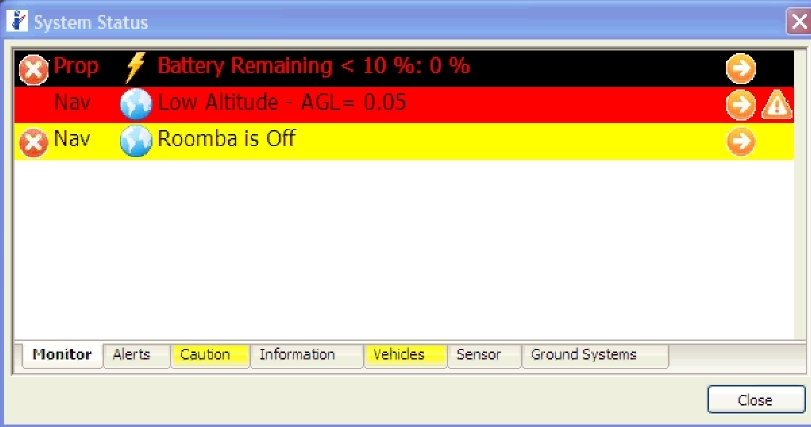
The Advanced Status panel not only informs the operator when situations arise requiring their attention, it also supplies them with a fully interactive checklist wizard that guides them through the corrective action necessary for specific problems.
The Advanced Status panel not only informs the operator when situations arise requiring their attention, it also supplies them with a fully interactive checklist wizard that guides them through the corrective action necessary for specific problems.
The map supports vector and raster formats- including CADRG, ADRG, CIB, geotiff, vpf and S57- as well as DTED(all levels) and DEM terrain models.
News: